It's not a short one this time.
Herein: Updates on the future of OIM, some good ol' tech improvements, new blog post, and community notes. For new readers, welcome! And here are all past newsletters in case one isn't enough.
2026 and what it will look like
In mid-January, I will be leaving my position at the Healthy Regions & Policies Lab where I have been for the past 2½ years, leading or contributing to elements of meaningful efforts like the SDOH & Place Project, OEPS, and Chives). I've worked with wonderful people and learned a LOT, but plan now to return to freelance consulting for a bit through my own company Legion GIS, and figure out what comes next.
With that in mind, I'm beginning to lay the groundwork for upgrades and enhancements to OldInsuranceMaps.net, and in the new year will be looking to 1) solicit one-off funding for specific efforts, and 2) create a new sponsorship model to provide more sustained support. As always, I am also open to larger institutional funding and collaborative opportunities.
Roadmap, a.k.a. wishlist:
- Ability to load maps from other collections, an oft-requested enhancement!
- A new map "request hub", to better track community requests and interest in particular volumes
- A new and improved web viewer for all maps in a given city
- More ways to visualize and explore statistics around the work that has been performed on the site (a small example of this below)
- Text extraction and search framework
- Comments, favorites, tagging, reporting issues, and other social things
If you or your organization would like to help make one of these happen (or have other ideas), please get in touch! You can reply directly to this email.
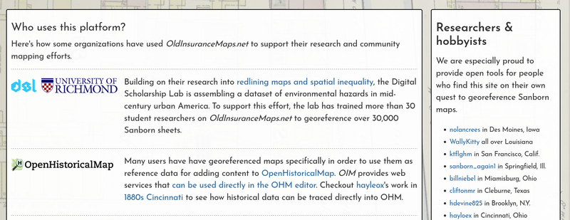
Who uses OldInsuranceMaps.net?
The home page now includes a new section, who uses this platform?. I encourage you to check it out, as the list was longer than I even thought (over a dozen orgs and many individuals) and it was gratifying to put together. There are a few other in-progress collaborations that I hope to add soon.
Improvements to the "multimask" interface
I made a few small improvements to the interface that you can use to trim margins of adjacent georeferenced layers, which I call a "multimask" within the platform. Checkout this recent blog post (Re)Introducing the Multimask Interface to learn more about how this works (it has a bunch more animated gifs too!).
Is that... a leaderboard??
Every time we have a georeference-a-thon, some rogue georeferencer or especially competitive couple asks if there is a leaderboard. There kind of was, just a list of all users with numbers on the platform, but it was an old page and took forever to load. Moreover, it always ended up with Ibrahim or Nate or WallyKitty at the top which (while impressive!!) wasn't very useful for events where new folks were working on one map all together.
So now there is a Stats table scoped to each Map, which you can find within the Summary section. I'm sure this will evolve over time, but for now it is a fun, quick (and sortable) way to see who has been working on content. Also, that original profiles page is now a lot faster.
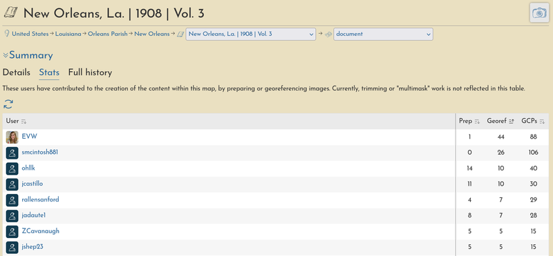
Since the beginning, I've deliberately not gamified this platform. I figured why not see how far we can get without all of that. That said, there is a side of seeing this information that tells the story of who has done the work, which is a core tenant here, so I do hope to add more elements like this in the future. Who knows, maybe we'll have georeferencing capitáns at some point too.
Faster tile loading
I implemented TiTiler on AWS as a Lambda service, rather then running it in a Docker container on the main server. If any of that makes sense to you, you are probably just surprised it wasn't already setup that way. Well, now it is!
There are still more tweaks to make (thanks for the tips, Eliot!), but already you should notice that the mosaic previews with 100 layers will load those layers all at once, instead of incrementally which was one of the limitations that came with the previous setup, and kind of a drag.
Community notes
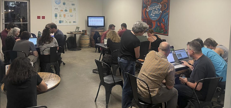
Georeference-a-thons in New Orleans
In mid-September, in collaboration with the Midlo Center for New Orleans Studies we held two back-to-back georeference-a-thons here in New Orleans, and our usual location of Second Line Brewing. Over the course of two evenings, about 30 people came, with only one person coming both nights (shoutout scanlan!). We worked on New Orleans, 1896, vol. 2, and vol. 4. The latter was especially fun because we split the tables into Carrollton, Gretna, Algiers, and 9th Ward.
A huge thanks to everyone for coming out! We focused on these volumes in particular because the UNO archaeology crew had just done work in Duncan Plaza, so Elizabeth shared some slides about the research and what they had found.
MapRVA presents: Yesterdays
A small and mighty team, MapRVA is an OpenStreetMap group in Richmond, VA, and a few months ago they began developing a new community project called Yesterdays. It is a fantastic crowdsourcing application for geolocating historical photographs of Richmond. They have already placed 5,000 photos!
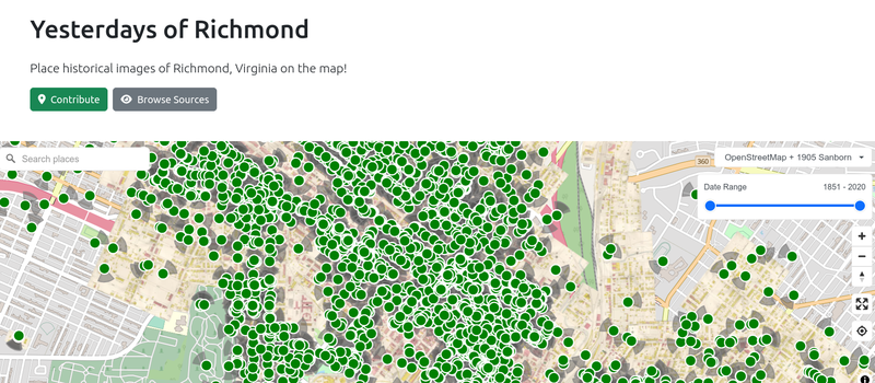
I learned about Yesterdays when they incorporated mosaics of Sanborn maps made in OldInsuranceMaps.net directly into their interface, which has proved an essential point of reference for placing historical photos. They've done more georeferncing since to add more layers--John just georeferenced all of 1925, vol. 2 in a couple of days by himself!
That's all for now, thanks for reading!
You can follow this project on Bluesky @oldinsurancemaps, or for folks on the OpenStreetMap US Slack, find the new #oldinsurancemaps channel.