Hello everyone and welcome to the final newsletter of 2023! It was last January that I made an announcement letting you all know we were back in business here, and since then a lot of wonderful things have come from the project. First, a couple of recent things I haven't yet told you about...
As always, you can reply with comments or questions directly to this email (it won't be a "reply all"!), or view past newsletters here.
On Development Seed's Blog
Over the course of the year I worked with Kiri Carini and Sanjay Bhangar at Development Seed to create a post about OldInsuranceMaps.net, and we finally released it on Dec. 1st: Open Source Spotlight: Old Insurance Maps. This year I completed a transition to using DevSeed's open source software, TiTiler, to serve all raster layers and because it is typically used for tiling satellite imagery, they were excited to see my use of it for historical maps. The blog post is one of the more detailed things I've written about the tech side of the platform, I encourage you to check it out!
On Maps Mania Blog
A few days after that, the Maps Mania blog (which I have followed for a while and I highly recommend to anyone who likes maps) also featured OldInsuranceMaps.net in a nice post, Historical Sanborn Maps of America. Very happy for this exposure, though there's nothing to make you feel like you need to improve a home page like all of a sudden having a hundred new people look at it :/.
Boring But Very Important: Upcoming CC BY License Implementation
As more institutions have started using the platform to georeference content, it's time to formalize licensing for content that is created on the site. At its heart, this is a collaborative crowdsourcing platform that facilitates the transformation of, access to, and public engagement with historical map content. With this in mind, I plan to implement the CC BY 4.0 license for all georeferenced content that is created on OldInsuranceMaps.net. Creative Commons licenses offer a formal way to ensure that content is shareable, and the BY extension requires only that attribution be given when the content is used in other contexts. When I finalize this decision with a statement on the website, I'll provide more info on how to give credit (probably something like "OldInsuranceMaps.net contributors, a la OpenStreetMap").
Once implemented, the CC BY 4.0 license would be applied to the following (existing and future) content on OldInsuranceMaps.net:
- User input data: cut-lines, ground control points, and trim mask coordinates.
- Geospatial datasets derived from this data: georeferenced layers and full trimmed mosaics.
Generally, this content is all free and downloadable already, so I see the CC BY 4.0 license as a way to formalize what has already been in place for almost 2 years now.
That said: If you have georeferenced maps on OldInsuranceMaps.net and you do not want this license to be applied to your work, then I have absolutely no problem with helping you download everything you've created and then I will remove it from the site.
Finally: If you have experience with CC licenses and/or licensing for crowdsourced content, I would love to hear your thoughts on this! Just reply directly to this email.
2023 Stats and Summary
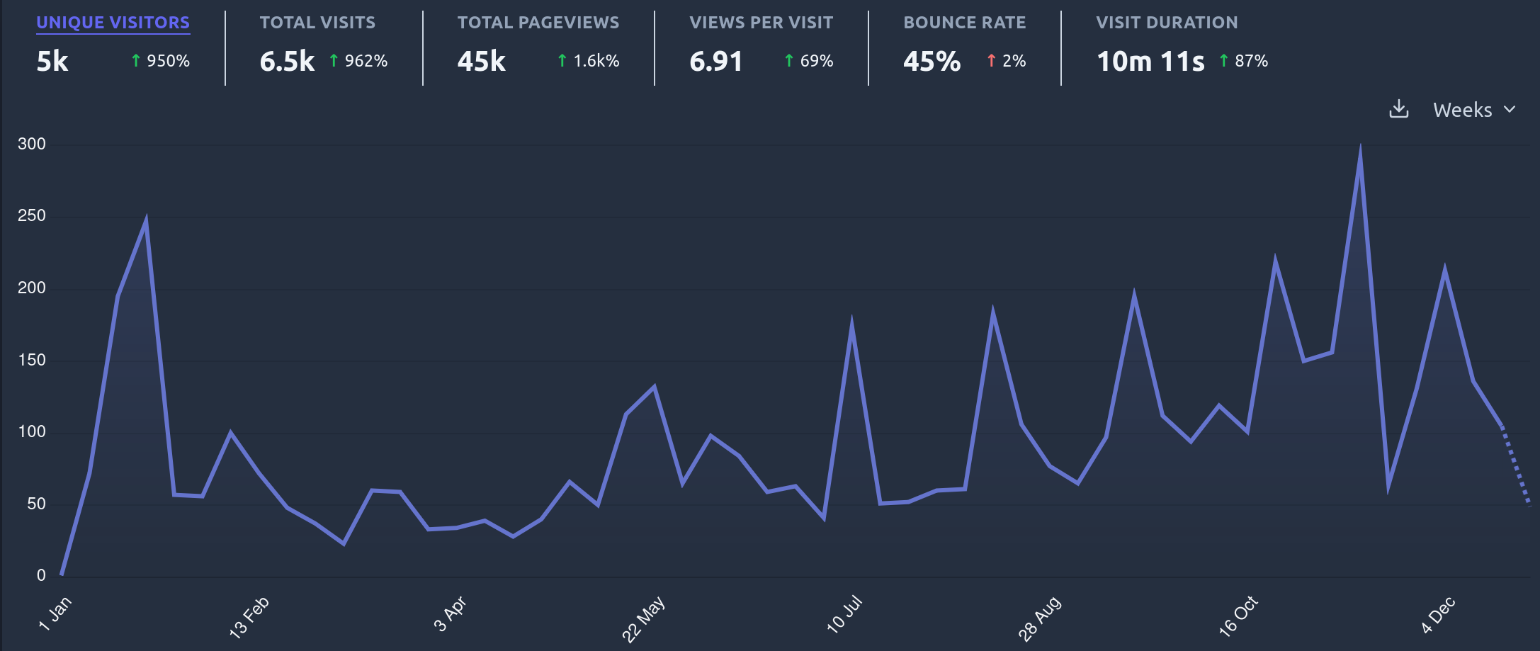
Now that that is out of the way, back to the year-in-review with some stats and graphs. Over the last year, OldInsuranceMaps.net has received ~5,000 unique visitors. Most importantly, the trendline is clearly going up (spikes correspond to newsletters, georeferencing-events, etc.).
Visitorship is one thing, but what about the georeferencing?? Overall, 4,500 new layers have been georeferenced this year.
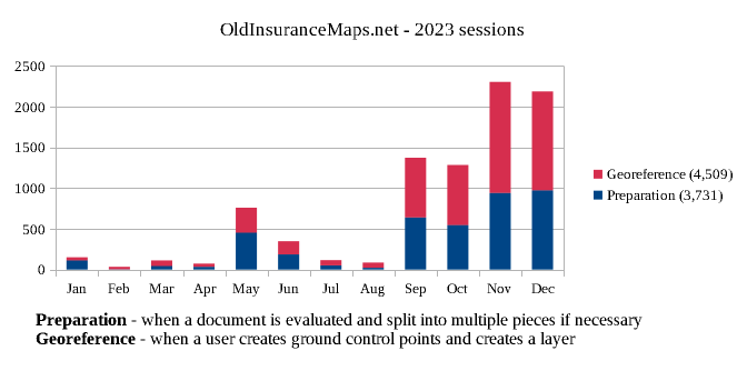
Of course, a huge proportion of that is the incredible effort by students and staff at the University of Richmond DSL starting in September (this work continues). We'll have much more about this effort and what it is achieving in the future. For now, I'll just shoutout Riley for managing this effort, and to the top-notch georeferencers involved:
wendyle, samyoga, nayers, 10varun17, jattys, JacksonSB, Shelby_m_richards, mekletb, amara017, mirandam, AYAH, and NyKyaSM (sorry if I missed anyone!).
But there have also been a lot of great independent efforts over the last year that I'd like to highlight. For example:
- Nolan in Des Moines, IA
- Kevin in Macon, GA (and many other nearby towns)
- Tod in Salt Lake City, UT
- tagifford in Schenectady, NY
- Ian in St. Paul, MN
- Jason in Essex County, NJ
- Pete in Menlo Park, CA
I know there are a handful of other folks who have request maps be added but haven't gotten a chance to work on them yet, so look out for much more in the coming year!
Georef-a-thons
We held two small events at Second Line Brewing in New Orleans this past summer, especially to support HistoryForge's use of the site for their New Orleans project (more HistoryForge collaboration coming next year). We created a beautiful mosaic of a 1896 New Orleans volume (and had a few beers too).
Then, in November, Josh and Michelle at Ohio State University held a GIS Day event where they had 30 people participate and georeferenced almost 200 sheets of Columbus maps in 4 hours! I'll be able to share a nice write-up in the next few months, and they already have another event planned for International Love Data Week.
Thanks for a great year!
Finally, a huge thank you to people this year that helped out, gave advice, or got involved some way or another, in addition to all of the contributors listed above... Jeff Meyers at OpenHistoricalMap; Eve Snyder and Elizabeth Williams at HistoryForge; Rob Nelson and Riley Champine at University of Richmond DSL; and Josh Sadvari at OSU Libraries... to name just a few. The project owes much to you all!
It's been a great year, and I have no doubt 2024 will see a huge expansion of the usership, engagement, and georeferencing capabilities on the platform.
Happy New Year!
Adam
p.s. I've just run out of time and space to describe the tech updates that the past year has seen... if that interests you, see the DevSeed blog post linked above.